
Death Valley, located in the Mojave Desert in southern California near the border of California and Nevada, is known for its extreme temperatures and for being the lowest point in North America. However, you will find plenty of diversity here: canyons, colorful rocks, sand dunes, salt flats, craters, ghost towns, and even a year-round waterfall. If you happen to visit in spring, you will find wildflowers covering this barren landscape. In other words, there is nothing deadly about the Timbisha Shoshone native land. This guide to Death Valley will tell you everything you need to know to plan your trip. Let’s begin.
I don't gatekeep good travel finds — I only share places and resources I genuinely use and love. This post may feature affiliate links, which means I may earn a small commission if you make a purchase at no extra cost to you. It helps me keep creating free travel resources on Curious Wanderess. Thank you for supporting my work, the occasional glass of wine, and Loki’s snack fund.
Death Valley history in a nutshell
Death Valley is home to the Timbisha Shoshone American Indian tribe that occupied the land for thousands of years. Since 2000, 7,000 acres of land in Death Valley and the surrounding areas have been officially recognized as their land. They have a tribal center on a 40-acre tract at Furnace Creek.
The name Death Valley was first given to the place by European settlers. They entered the valley in 1849, trying to make a shortcut to California. After barely surviving their journey through the valley, they gave it the name we know today. Death Valley was first proclaimed a national monument in 1933 due to its natural beauty and scientific importance. In 1994, an additional 1.3 million acres were added to the park, and Death Valley was officially declared a national park. In 2019, an additional 35,000 acres were transferred to the park.
If you’d like to learn more, stop by Furnace Creek to watch a short, educational video.
What to do in Death Valley
Furnace Creek Area
- Dante’s View: Dante’s View offers a panoramic view of Death Valley overlooking Badwater Basin. Wander around on a one-mile trail and take in the view from different angles.
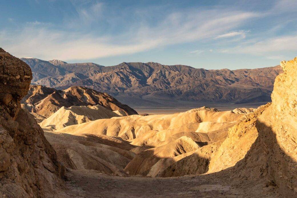
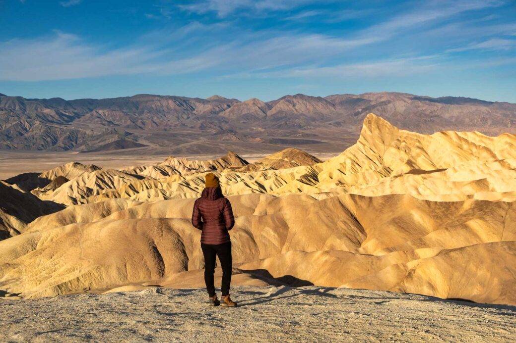
- Zabriskie Point: Zabriskie Point is an iconic spot with vibrant, golden colored badlands and mountains in the background. Take a closer look at the badlands by connecting to surrounding hiking trails.
- Golden Canyon: Hike slot canyons surrounded by golden rock formations. Admire the layers of rocks and mountains in the distance. Connect to Gower Gulch or Badlands Loop to hike around colorful badlands and reach Zabriskie Point.
- Natural Bridge Canyon: Take a short hike to Natural Bridge Canyon. Find the most impressive natural bridge in Death Valley, standing 35 feet above the ground and a dry waterfall.
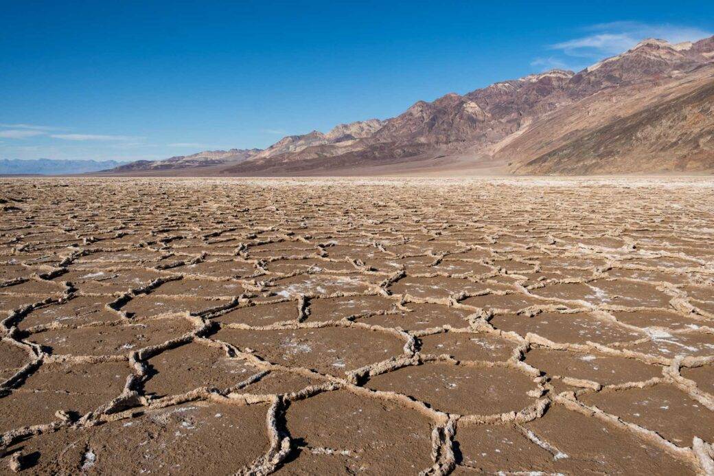
- Badwater Basin: Explore Badwater Basin, the lowest point in North America at 282 feet (85.5 meters) below sea level. Walk on the boardwalk for a closer look at the salt flats patterns.
- Devil’s Golf Course: Stop by Devil’s Golf Course to look at crystallized salts, a residue of Death Valley’s last lake. There is no hiking trail here, but you can examine the surface on your own.
- Artist’s Drive and Artist’s Palette. Take a ride on Artist’s Drive, a 9-mile (14 km) one-way road that takes you through colorful rock formations. The highlight is Artist’s Palette. You will find hills in shades of green, pink, purple, yellow, and blue.
- Harmony Borax Works. Learn a bit about Death Valley history at Harmony Borax Works, where borax operations from the late 19th century are on display. Here you will learn about borax, “the white gold of the desert.” Borax was the most profitable mineral found in Death Valley.

Stovepipe Wells Area
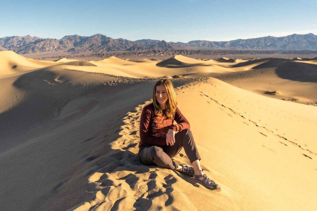
- Mesquite Flat Dunes. If you’re going to explore sand dunes, stop by Mesquite Flat Dunes. These dunes reach up to 150 feet (46 m) in height and are surrounded by mountains. Mesquite Flat Dunes are easily accessible compared to other dunes in the park, which require a four-wheel drive vehicle.
- Mosaic Canyon. Mosaic Canyon is a perfect spot for geology fans and adventure seekers. Explore nature’s murals by walking through the narrows to the canyon.
- Salt Creek. Salt Creek is a creek running through the Death Valley desert. Follow a wooden boardwalk to find signs of life at Death Valley.
Panamint Springs Area
- Darwin’s waterfall. Darwin’s Falls is a year-round waterfall in Death Valley. You will find it in a canyon surrounded by lush green vegetation. A short hike will take you here.
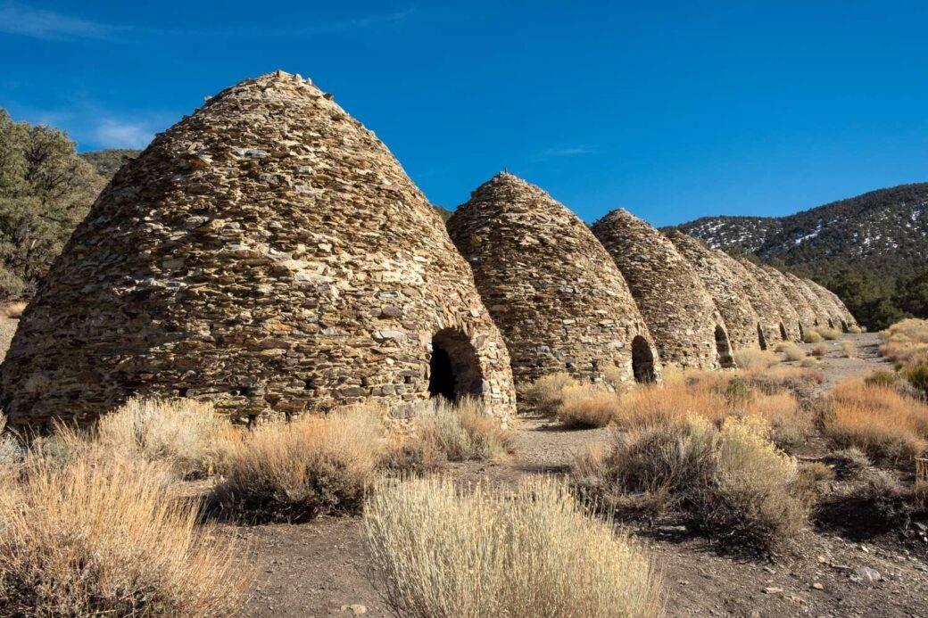
- Wildrose Charcoal Kilns. Wildrose Charcoal Kilns from the 19th century produced charcoal for two silver mines. The kilns were in operation for only three years. They are considered the best-preserved kilns in the West due to their location and limited use.
- Racetrack Playa. Racetrack Playa is a dried lakebed nested between the mountains with mysterious sliding rocks. You will need a high-clearance vehicle with heavy-duty tires.
- Aguereberry Point. Aguereberry Point, sitting at 6,433 feet (1,961 m) high, offers one of the most expansive vistas of Death Valley. You can see the white salt flats of Badwater Basin, the oasis at Furnace Creek, and Mount Charleston from here.
- Ubehebe Crater. Ubehebe Crater is the largest and youngest crater in Death Valley. It is the result of a volcanic explosion and is up to 0.5 miles (0.8 km) in diameter and about 500 feet (153 m) deep.
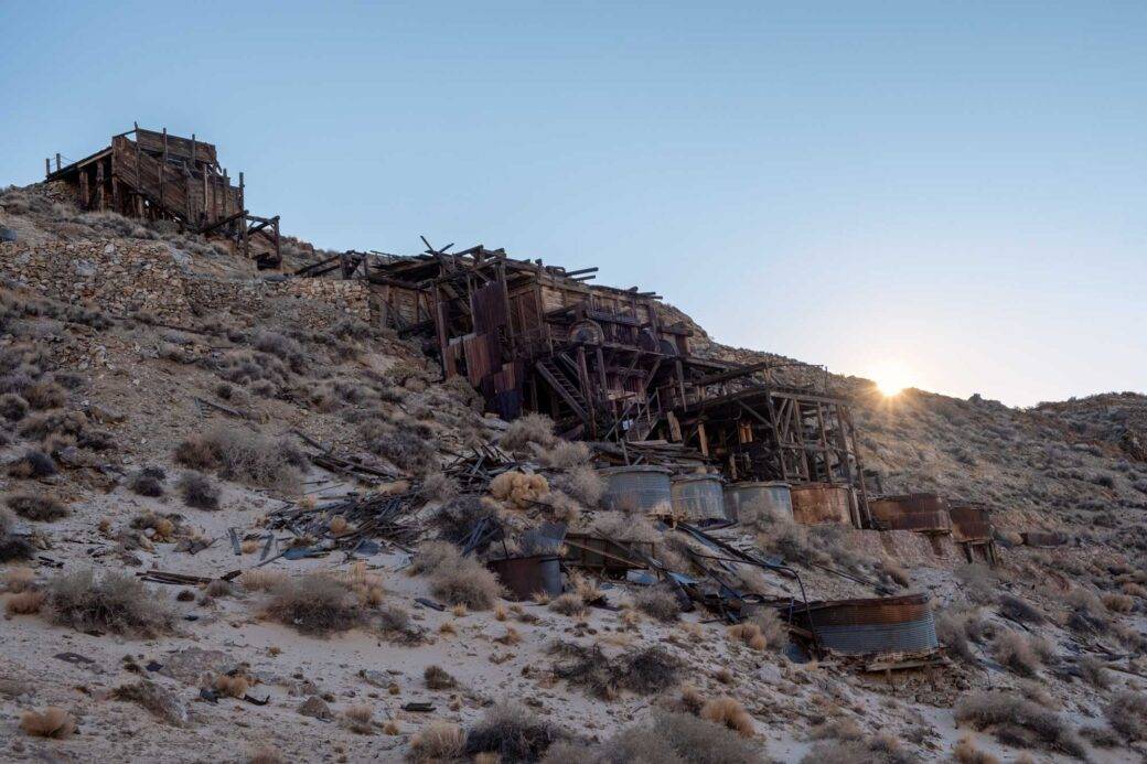
Ghost Towns
Complete your trip to Death Valley by stopping by one of many ghost towns. You will find several ghost towns spread throughout Death Valley and the surrounding areas. Some are easier to access than others, for which you either need a high clearance vehicle or need to hike. The ghost towns vary in size. Their rustic machinery and wood serve as a reminder of Death Valley’s history.
Ghost towns in Death Valley
- Ballarat
- Chloride City
- Greenwater
- Harrisburg
- Leadfield
- Panamic City
- Rhyolite
- Skidoo
How to get to Death Valley
By plane
The two largest cities close to Death Valley are Las Vegas and Los Angeles. There is a small airport at the park at Furnace Creek, but it is only for private planes. The closest airport outside the park is McCarran International Airport in Las Vegas, 120 miles southeast of the park. The second closest airport is Hollywood Burbank Airport in Los Angeles, 200 miles southwest of the park.
By car
California Highway 190 crosses the park from east to west. The route you take depends on what direction you are approaching Death Valley from.
- Nevada: take US 95. From US 95, you can connect to highways at Scotty’s Junction (Nevada State Route 267), Beatty (Nevada State Route 374), and Lathrop Wells (State Route 373).
- Las Vegas: the closest route is via Pahrump, Nevada, and then California Highway 190.
- California: take Interstate 15 to Baker (State Route 127), then to Death Valley Junction (California Highway 190).
How much it costs to visit Death Valley
There is a fee to enter Death Valley National Park. The price varies per vehicle, per motorcycle, and per individual. All passes are good for 7 days upon entry. You can pay online or at fee machines using a credit card. You will find a kiosk at the east entrance to the park on Highway 190, at Furnace Creek, at certain campgrounds when open, or at a few points of interest such as Zabriskie Point or Badwater. The America the Beautiful Annual Pass, along with other federal recreational passes, is accepted as well. For additional information, including current fees, fee station locations, and annual passes, refer to the national park website.
How many days is enough for Death Valley
Death Valley covers a large area. Depending on your interests, you might want to spend from one to three days there. Most popular points of interest are near Furnace Creek and could be visited in one day. However, if you want to take a slower pace and add some hiking, 2 days would be ideal. To get to more remote locations and enjoy some sights all to yourself, I suggest 3 days. Note that some attractions will require a four-wheel drive vehicle. However, two days should be sufficient to see the most popular and easily accessible spots without rushing.
Best time to visit Death Valley
The best time to visit Death Valley is from November to March, when temperatures are more bearable, especially if you plan to hike or camp.
- Winter. Winter is a great time to visit. Although mornings are rather chilly, it warms quickly, especially at lower elevations. Temperatures reach up to 70°F (20°C) and are optimal for hiking. The mountains are covered in a blanket of snow, making them more striking. Days are shorter, which is perfect if you’d like to catch a sunrise without getting up too early. The park also tends to be quieter if you visit outside of holidays such as Christmas or MLK Day.
- Spring. Spring is also a good time to visit, but April temperatures can reach 90°F (32°C). If winter brings rain, the biggest park attraction are wildflowers. The wildflowers bloom from late March to early April. Keep in mind that this is also spring break time, bringing a lot of tourists to the park.
- Summer. Summer can be dangerous and life-threatening, with temperatures reaching 120°F (49°C) during the day and cooling to only 100°F (38°C) at night. This is a time to focus on sightseeing by car and stopping only at points of interest. There are two hikes that are accessible this time of year: Wildrose Peak and Telescope Peak. I would avoid hiking and camping altogether in low elevations and focus on low-elevation attractions early in the day.
- Autumn. Autumn starts in late October with more bearable temperatures. Except for Thanksgiving, this is a good time to visit to avoid crowds, as the park tends to be quieter in the autumn months.
Where to stay in Death Valley
Death Valley comprises 3.4 million acres, making it the biggest national park in the lower 48 states. You will do a lot of driving while in the park. I recommend staying in the park.
Hotels in Death Valley
- The Oasis at Death Valley. The Oasis at Death Valley includes the Inn at Death Valley and the Ranch at Death Valley. They are both just a few minutes from the Furnace Creek Visitor Center and its attractions, including Zabriskie Point and Golden Canyon. The inn is the most pricey and luxurious accommodation available in the park. Built in 1927, it features a swimming pool, gardens, a tennis court, a spa, a sauna, and a fine-dining restaurant. The Ranch at Death Valley is a more affordable option. It features a buffet, bar, coffee shop, general store, golf course, swimming pool, basketball court, tennis court, gas station, and the Borax Museum.
- Stovepipe Wells Village. Stovepipe Wells Village lies in the heart of the park, 30 minutes northwest of Furnace Creek. The closest attractions are Mesquite Flat Sand Dunes and Mosaic Canyon. The village features a swimming pool, restaurant, general store, saloon, gas station, and RV park with hookups.
- Panamint Spring Resort. Panamint Spring Resort is on the western side of the park, an hour from Furnace Creek. This rustic western-style resort features a restaurant, general store, campground with tent and RV sites, motel, and gas station.
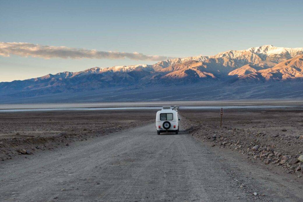
Van life in Death Valley
If you’re traveling in an RV or a campervan, RV hookups sites are available at Furnace Creek Campground, Stovepipe Wells RV Park, and Panamint Springs Resort. You cannot camp at trailheads within the park. Camping is allowed on unpaved roads at least one mile away from any paved road or “day use only” unpaved road. Before camping, refer to the restrictions listed on the Death Valley National Park website.
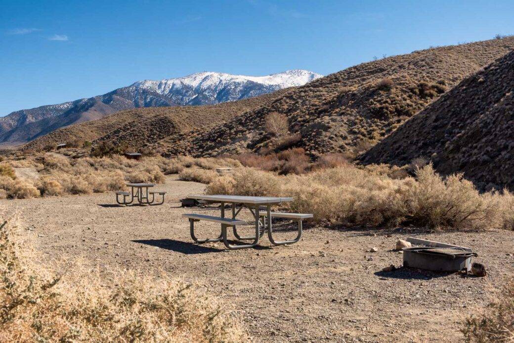
Campgrounds in Death Valley
Outside of backcountry camping, Death Valley features 9 established campgrounds. Campgrounds at elevations up to 1900’ require a fee, while the others are free. All campgrounds operate on a first-come, first-served basis except for Furnace Creek, which takes reservations.
Lower Elevation Campgrounds
- Furnace Creek (-196’; -60 m)
- Sunset (-196’; -60 m)
- Stovepipe Wells (sea level)
- Texas Spring (sea level)
Furnace Creek is the only campground in the valley floor open all year. The others are open from October to May.
Higher Elevation Campgrounds
- Mesquite Spring (1,800’; 549 m)
- Emigrant (2,100’; 640 m)
- Wildrose (4,100’; 1,250 m)
- Thorndike (7,400’; 2,256 m)
- Mahogany Flat (8,200’; 2,499 m)
These campgrounds are open all year except for the two at the highest elevation, Thorndike and Mahogany. They are open from March to November.
Where to eat in Death Valley
There are several options to eat in the park. If you’re road tripping, I encourage you to bring a cooler with food. Food in Death Valley tends to be pricey and spread apart. Depending on your itinerary, you might have limited opportunities to stop for food during the day. Furthermore, most restaurants and general stores have limited hours of operation and take breaks between serving breakfast, lunch, and dinner. You will also not find picnic tables in the park outside of campground areas. Bring your own camping equipment, along with a cooler with food.
Your food options in the park are as follows.
Furnace Creek
- Inn Dining Room is the fanciest option in the park. This fine dining restaurant is open for breakfast and dinner. A reservation is required, and you need to follow a dress code to dine in.
- The Ranch 1849 Buffet is open daily for breakfast, lunch, and dinner. It offers a variety of hot and cold options that vary daily.
- Last Kind Words Saloon is a bar that serves drinks and a bar menu nightly.
- Ice Cream Shoppe serves coffee, milkshakes, and sodas. Hot food services begin at 12 and include hot dogs and hamburgers.
- General Store offers gifts, sandwiches, wraps, snacks, groceries, and camping supplies.
Stovepipe Wells
- Badwater Saloon serves a buffet breakfast and dinner.
- General Store offers gifts, sandwiches, snacks, groceries, camping supplies, and firewood.
Panamint Springs
- Dining and Bar serves breakfast, lunch, and dinner with patio seating.
- General Store offers gifts, snacks, camping supplies, and firewood.
How to navigate Death Valley
There is no public transportation to the park. A motor vehicle is essential to get to the park and to navigate inside the park. You may even need a high clearance, four-wheel drive vehicle to access some of the unpaved, backcountry roads. Be sure to inquire about driving on unpaved roads when renting a car, as most rental companies restrict your contract to paved roads only.
Most popular Death Valley attractions are accessible via paved roads. However, if you decide to explore attractions hidden behind paved roads, you can rent a jeep from Farabee’s Jeep Rentals across the street from the Inn at Death Valley.
Gas stations at Death Valley National Park
- Furnace Creek: unleaded and diesel
- Stovepipe Wells Village: unleaded only
- Panamint Spring Resort: unleaded only
PRO TIP. I encourage you to fill your gas tank before arriving at the park, as gas prices are inflated. They are almost double at some gas stations. I found Furnace Creek to be the most expensive option on my last visit. It is worth looking around for opportunities to save money.
Overall
I hope the unique landscape of Death Valley will impress you as much as it impressed me. Let me know in the comments if there is anything missing from this guide to Death Valley.
No comments